Release of GST 3.13
Dezember 18, 2023 12:32 p.m.Welcome to the release of GST 3.13. This release contains all developments through 2023. Some of them have been made available with GST 3.12 to some of our clients, and now they will be available to everyone.
We have extended GST at large to increase its interoperability, especially with building information management (BIM) and other modeling packages, by adopting IFC and RESQML. Moreover, we have added functionality to allow for a semi-automatic stratigraphic ordering.
Here is a quick list of what has changed in GST 3.13!
- Segmentation for stratigraphic grids
- Simplification of meshes
- Stratigrahic ordering
- External Earthquake data
- Enhanced interoperability with BIM and more
- Visualization of a complete borehole
- Visualization of borehole logs
- Filter boreholes on the fly
- Improvements for textured geometries
- Improvements of GST Desktop
- Improvements of GST Web
Furthermore, we tweaked a lot to make GST Server, GST Desktop and GST Web easier to use and respond faster. And, as usual, a couple of bugs have been eliminated under the hood. Take a look at this blog post to learn more about each individual feature, or let us know what you think about these changes on Twitter @GiGaInfosystems or email us (support@giga-infosystems.com) or use our contact form.
Segmentation for stratigraphic grids
Stratigraphic grids (SGrids) or geological grids, as they are also referred to, can now be segmented based on their parameter distribution. This allows you to group areas within a value range into new regions. This procedure is also called iso-surface generation.
This functionality can be activated in GST Web as a new display mode for SGrids. Moreover, it allows switching off and on the generated iso-surfaces.
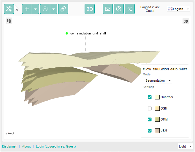
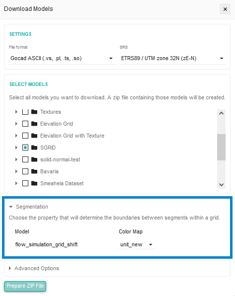
This feature is also available as a download option:
Simplification of meshes
We know that geological features tend to get bigger. In contrast, a higher spatial resolution is also requested in order to be able to answer geological questions around geothermal heat pumps or nuclear waste deposits. Even GST Web can struggle to display all the big geological features at once.
We are happy to share our simplification feature with you today. GST 3.13 adds a fast and effective algorithm for mesh simplification. It is designed to reduce the number of triangles in a mesh while preserving its overall shape, ensuring that the integrity and accuracy of the mesh are maintained.
The mesh simplification feature has been integrated as a download option into GST Desktop. An additional option has been added to keep border triangles intact during the simplification process. This ensures that the edges and boundaries of the mesh remain unaltered.
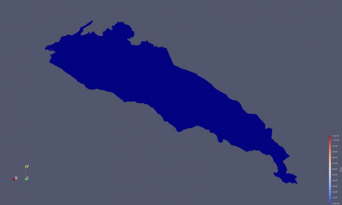
See the below images for a comparison:
Before the simplification was applied, the geometry consisted of many regular triangles. Each edge of the triangles is drawn in blue; hence, we have an almost completely blue feature.
After the simplification has been applied — with a simplification of 1% within a runtime of less than a minute — you can clearly recognize areas where only a few triangles are left over (brighter and bigger triangles) and areas where many triangles are used to properly describe the shape of the geological feature (dark blue and small triangles).
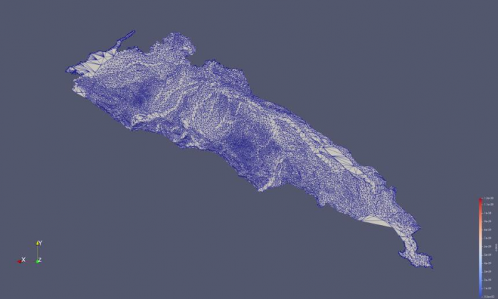
Especially with visualization in mind, this feature allows for the transmission of big geometries to the viewer while maintaining the overall shape and important geological features.
Stratigrahic ordering
With GST 3.6, we added support for alphabetic ordering in the model management. We are happy that in 2023 we were able to finally extend this functionality to sort not only alphabetically but also according to:
- Feature attributes
- Model properties
- Theme order
Moreover, we have added an auto-sort option that will re-sort the data whenever you update the underlying properties or ordering.
Within the virtual cross-sections and boreholes, we now have the possibility to add the model management parents as headings and adhere to the sorting applied prior.
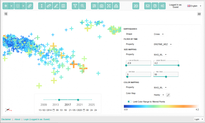
External Earthquake data
GST 3.11 already allows you to upload point clouds and visualize them efficiently in GST Web. With the 3.12 release, we added support for time stamps. GST 3.13 takes it even further and allows you to add external sources to feed GST Web with earthquake data.
Enhanced interoperability with BIM and more
Working closely with our clients and discussing their needs regularly allowed us to extend GST’s interoperability by a large margin. We have added quite a few import and export formats:
- 3d tiles — allowing to include geometries from GST directly into other viewers,
- IFC — connecting geological features with BIM,
- RESQML — allowing to import and export features to big modelling packages such as Petrel,
- NETCDF — include data from other sources, such as ESRI ArcGIS,
- 2d SEGY as GeoTIFF.
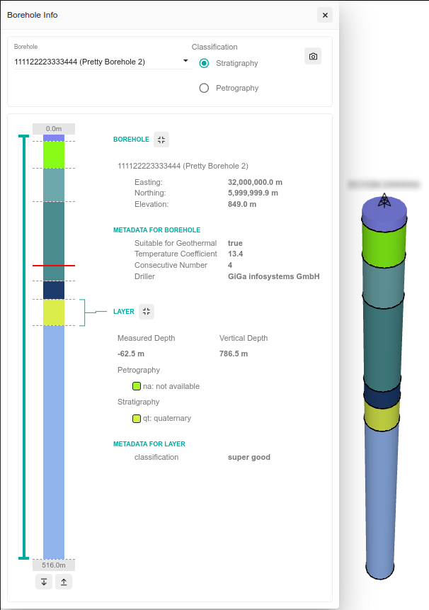
Visualization of a complete borehole
Our borehole module gained a lot of new functionality in past releases. With GST 3.13 we take it even further and allow for the display of the complete stratigraphy or petrography right in the informational dialog. The users can switch dynamically between the two representations and even click on each single layer to get specific information about them.
We adjusted the underlying datamodel to be able to transport arbitrary metadata, either with the borehole or with each layer. You can even use HTML or create links to stratigraphic dictionaries.
We have also added controls allowing you to select parts of the borehole that are of special interest. Navigating through a set of very thin layers can be easily achieved with the new buttons.
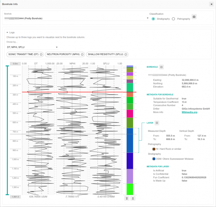
Visualization of borehole logs
But we did not only stop with the visualization of the complete borehole but also extended it to read the borehole logs from LAS data. GST Web now allows you to visualize up to three logs in parallel. If you have 3d features enabled in the normal view, their elevation is displayed as a horizontal line in the plot (c.f. figure 7, red line).
You can read the value of a specific log at certain depths by simply hovering it with the pointer.
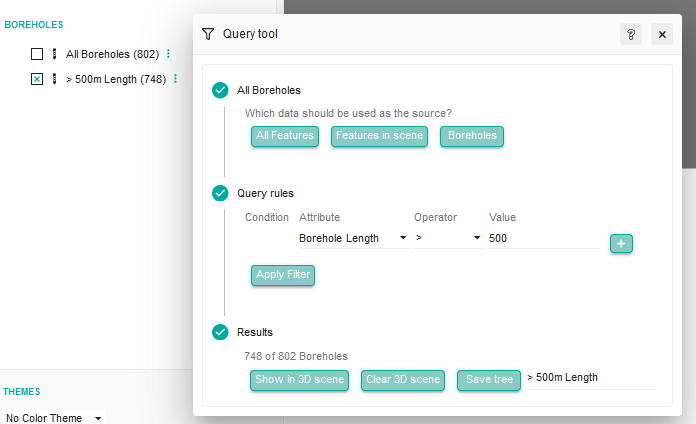
Filter boreholes on the fly
Since we rolled out GST Borehole with the initial release, we have seen an increasing amount of boreholes displayed with GST. Some client databases even have up to 1.4 million boreholes.
We understand that it is sometimes hard to find the proper boreholes. Therefore, we added the possibility to filter boreholes on the fly in GST Web.
You can now filter boreholes according to their length, their contained stratigraphy or petrography or by their identifiers. You can store the filters for your session and send them with a link to a colleague to share the same scene as you experienced.
The filter allows for combinations by „AND“ and „OR“ and supports wild card operators. Filtered boreholes are also used in all other functions, like profile creation or correlation plots.
Improvements for textured geometries
Users now have the ability to set the texture for their geometries during the upload process. Another notable improvement is the ability to read textures from associated Material Library Files (.mtl) when uploading Wavefront OBJ files.
Improvements of GST Desktop
- Distinct Feature Types have been introduced for ElevationGrid, Segy2D, and Segy3D, replacing the previous approach of using feature class tags for these data types.
- The histogram of property values now displays minimum and maximum values.
- The Feature List in the Global Selection dialog is now resizable.
- Actions for multiple Feature Classes now utilize highlighted feature classes instead of checked ones, mirroring a similar change previously implemented in the Browse Features dialog.
- In the event of a connection error, GST 3.13 now provides more detailed and informative error messages.
Improvements of GST Web
Updates to colormaps are now immediately recognized upon refreshing the webcache. This eliminates the need to clear and rebuild the entire cache for colormap changes to take effect in GST-Web.