Release of GST 3.11
März 9, 2023 10:37 a.m.Welcome to the release 3.11 of GST. This release marks the traditional cut with all development of the past year, 2022. Most of the development concentrated on improvement and extension of existing functionality. But there were also new features introduced: the support of point clouds, display of boreholes in cross sections, management of geological profiles.
Here is a quick list of what is new in GST 3.11!
- GST Web: Visualization of Point Clouds
- GST Desktop: Color Management
- Display Boreholes in Virtual Cross Sections
- Correlation Plots
- Management of Geological Profiles
- GST[AR] for Android
- Extended Shapefile Upload
- New Download Options and Formats
- Improvements for Spatial Queries
- GST Web Admin
- GST Web Manual
- Other Improvements
Furthermore we tweaked a lot to make GST Server, GST Desktop and GST Web easier to use and respond faster. And, as usual, a couple of bugs have been eliminated under the hood. Have a look at this blog post to learn more about each individual feature or let us know what you think about these changes on Twitter @GiGaInfosystems or send us an email (support@giga-infosystems.com) or use our contact form.
If you would like to try it out, we invite you to head over to our Demo at https://demo.giga-infosystems.com.
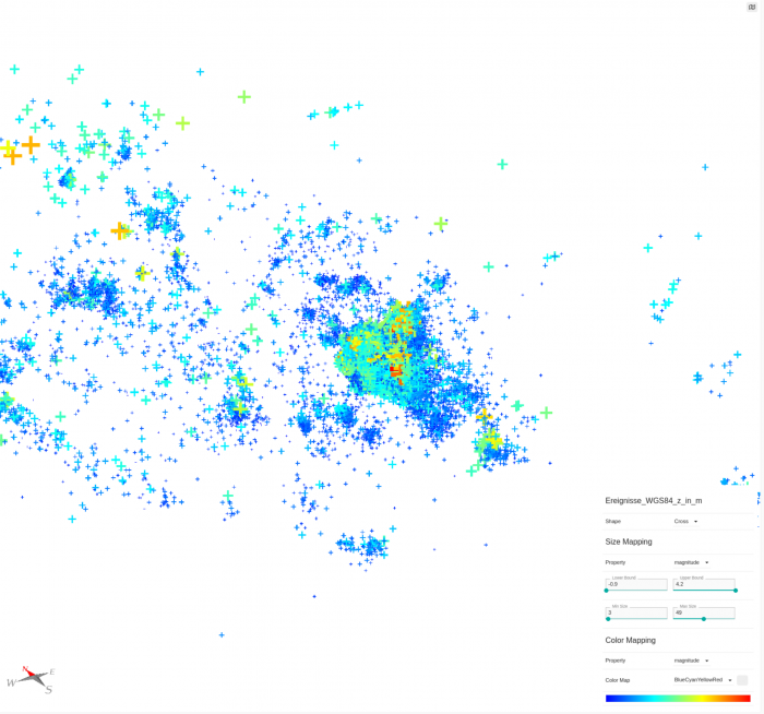
GST Web: Visualization of Point Clouds
Point Clouds have a lot of use when it come to geospatial data. This feature has been requested a lot in the past and is finally available to everyone.
Currently we allow to use a shapefile or Gocad ASCII file to be uploaded to GST and interpret it as point cloud. This means that all features in the file will be uploaded as multipoint feature into GST. Moreover the attributes of e.g. the shapefile will be mapped to properties of the feature class.
As always it was crucial for us to allow high-perfomant display of these point clouds – the GST Web rewrite of the past years allows that. Additionally, it allows on-the-fly mapping of properties for an interactive and immersive visualization of the point cloud. The users can select the properties, set the value range and with that change the colour or the size of the point features.
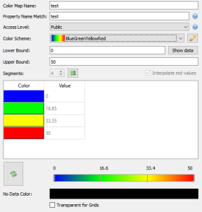
GST Desktop: Color Management
Until now GST had limited capabilities to define the color scales for Themes and Colormaps. Moreover there were only limited import and export capabilities.GST 3.11 extends functionality that allows users to define colors for Themes and Colormaps:
- Color Schemes
- Colors from joined Tables
- Improvements for Themes and Colormaps
Color Schemes
With Color Schemes it is now possible to store predefined discrete and continuous color schemes. More over we have added the capability to import and export such Color Schemes from so called Color Palette Table files (*.cpt). This allows you to easily import such color ramps from third party web sites but also to exchange these themes with other software like Esri ArcGIS Pro, Petex Move or QGIS.
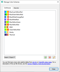
The previously defined color schemes can then be used to define the color maps or themes. Moreover they can be used as base to colorize a point cloud.
Colors from Joined Tables
We know that a lot of our users are using extensive data models in order to manage their geological data. Such models include lithographic and stratigraphic descriptions as well as meta data and symbols to be used.
With our newest release we not only allow referencing the data stored in such models but also the colors from for example a general legend table. If a feature has a constrained color, it will be used instead of the default color.
Our latest update allows you to seamlessly read such color information also for color maps and themes. They will work like normal color maps and themes but you do not need to input the same data over and over again saving you a lot of time. Moreover these tables will not be managed by GST and therefore allow you to use the system you prefer.
Improvements for Color Maps and Themes
To round up our changes for color management we also made it easier create discrete themes and color maps with floating point numbers. The applied matching is now less strict and e.g. allows to match a property values of „0.10000000149“ to an entry value of „0.1“.
Our latest update includes the ability to assign a theme to a feature class. This sets the feature colors equal to the color they have with the theme.
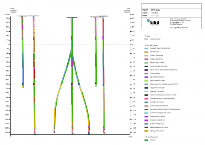
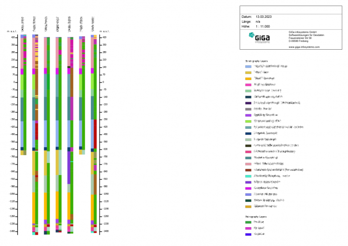
Display Boreholes in Virtual Cross Sections
Our latest update allows you to seamlessly connect geological boreholes from a service to the model data in GST. This integration empowers you to visualize borehole data alongside 3D geological data, providing you with a more comprehensive understanding of the subsurface.
We understand that sorting through vast amounts of borehole data can be time-consuming. That is why our latest update includes the ability to filter boreholes within a specified distance of an input linestring, so you can quickly access and analyze the most relevant data. Boreholes within the specified distance are orthogonally projected onto the cross section plane.
You can choose to display stratigraphy, petrography, or both in virtual cross sections, offering you the flexibility to see the specific geological data that matters to you.
The ability to output virtual cross sections as images makes it easier for you to share geological data and interpretations with others. Additionally, layer labels are displayed in the legend, making it simple for others to interpret the data presented.
Lastly, you can also output virtual cross sections as shapefiles, with borehole and layer information stored as attributes, giving you the flexibility to manipulate the data in other software tools.
Correlation Plots
GST Web now also allows to create so called correlation plots from selected boreholes. The boreholes can be selected visually on the map or via a comma separated list. Currently such correlation plots can be created as picture or shapefile depending on how you want to use it.
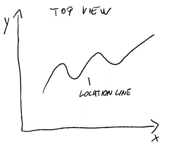
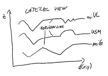
Management of Geological Profiles
Most of the current 3d models today are based on different kinds of data:
- Geophysical measurements
- Boreholes
- Outcrops
In many cases geo-scientist create so called profiles in 2d from the measurements or boreholes and interpolate them in 3d space. Profiles or cross sections are today still in major use in geosciences in order to transport a visual representation of the underground.
With our latest release GST introduces a new feature type: Profiles. These profiles have a specific meaning in GST Web and Desktop and provide you with different options while uploading and downloading. To allow this we introduced so called „Sub feature kinds“ which are like a feature class for the child features and therefore allow to transport distinct sets of attributes.
Today there are the following sub feature kinds for profiles available: Location Line, Horizon, Fault, Misc.
Currently GST supports to upload profiles from a set of shapefiles:
- One location line in 2d real world coordinates
- Horizon, faults, miscellaneous lines in profile coordinates. Where as „profile coordinates“ mean, that the x coordinate denotes the length/distance along the location line and the y coordinated denotes the height.
Additionally, we also developed a tool which allows you to upload several tens or even hundreds of profiles semi-automatically.

GST[AR] for Android
GST[AR] is a free Android app which allows you to browse, download, view, and share 3d geological models in augmented reality (AR). If you can’t wait to get your hands on this new experience, you can download the app straight away on any Android device that supports Google Play Services for AR: https://play.google.com/store/apps/details?id=com.gigainfosystems.gstar.
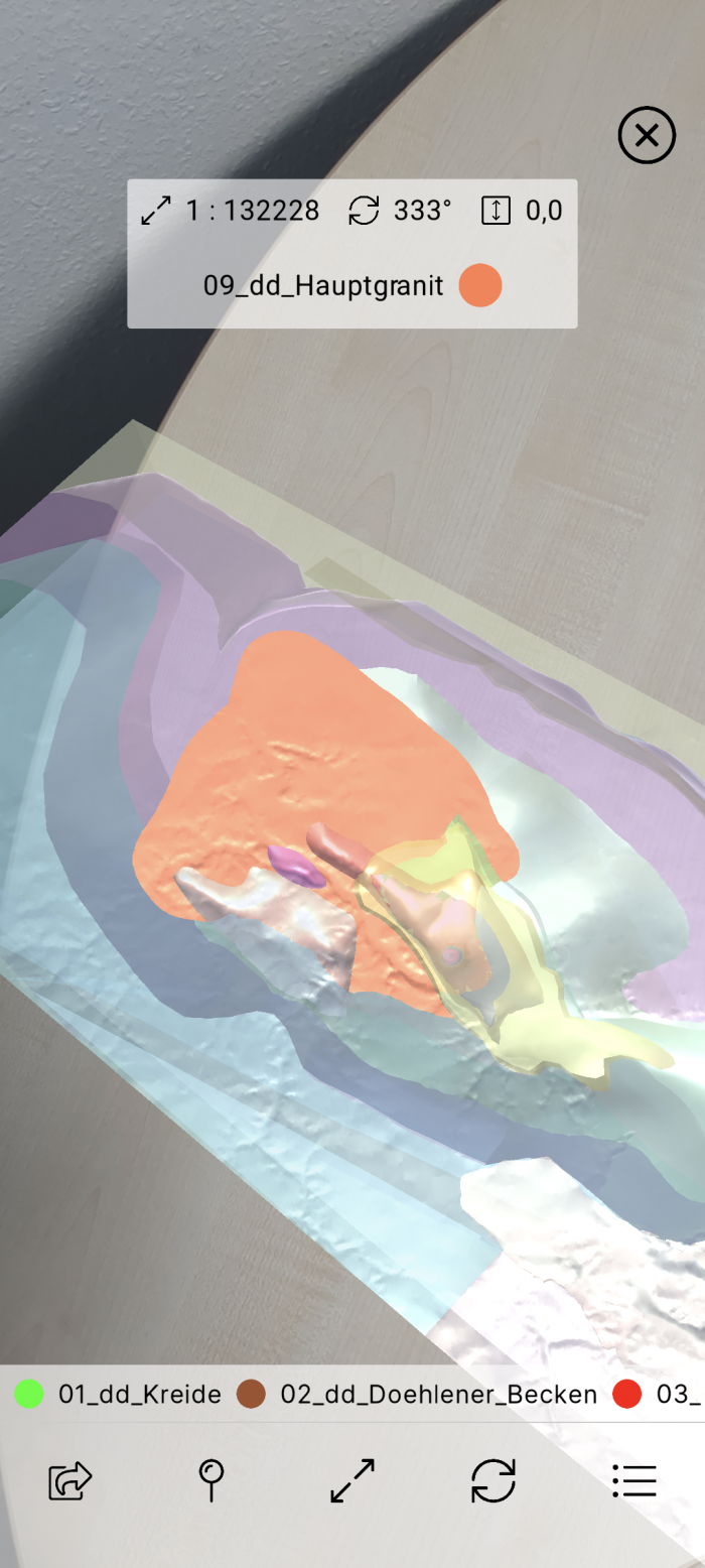
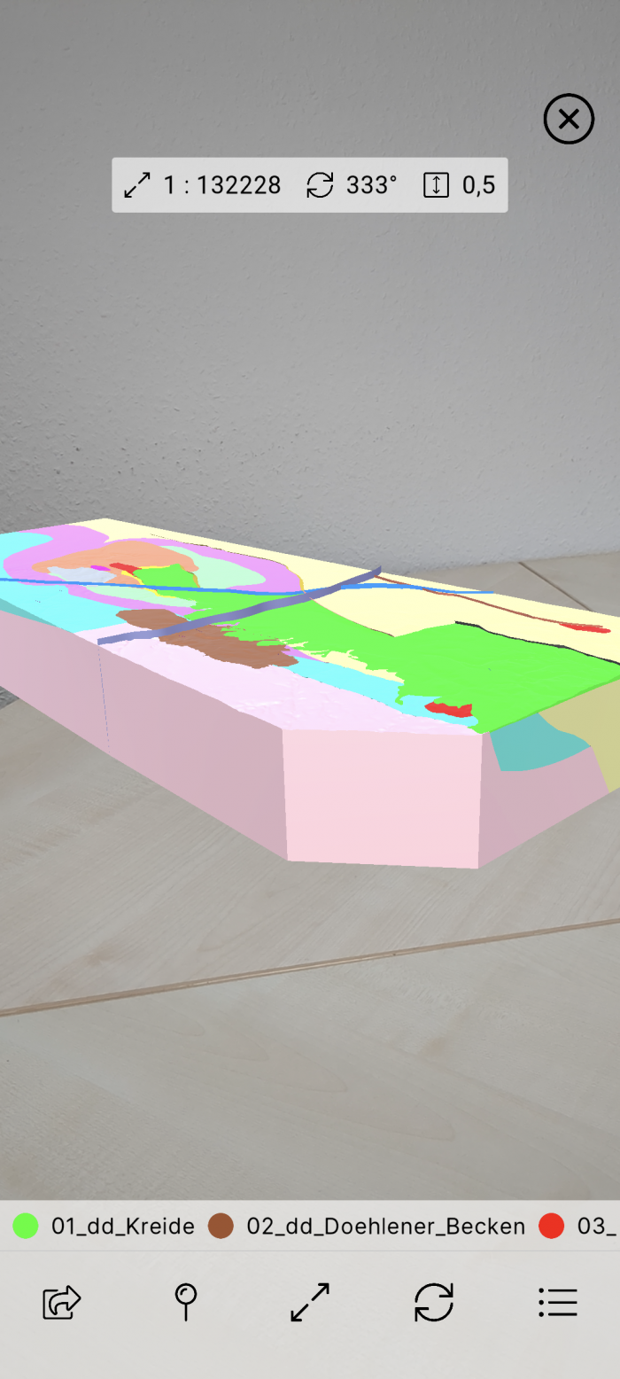
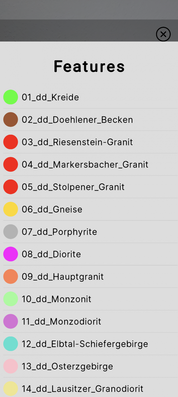
You can read more about GST[AR] for Android at: https://giga-infosystems.com/gstar-for-android.
Extended Shapefile Upload
With our latest release we introduced more options when uploading shapefiles. It now allows to upload all features of a shapefile as a single feature in GST with the „Shapefile Collection“ tag for point and line features. This allows you to upload many features from a shapefile and display them in GST as one single feature. Simultaneously you still can assign different attributes to the child features when browsing the features in the Browse Feature Dialog in GST Desktop.
Upon download we provide you the options to either get one single shapefile or a set of single shapefiles per feature.
New Download Options and Formats
GST 3.11 adds a couple of new download formats and options:
- We now can write seismic data as SEG-Y according the SEG Technical Standards Committee’s SEG-Y_r2.0 standard
- The original header can be stored as separate text file
- Most of our feature types can now be exported as glTF allowing you to use the models in other software like Blender or Cesium
- Another format that has been added allows you to view features from GST in Google Earth and other viewers: KML/Collada.
- In order to be able to view the large features in GST we added an option to apply some custom tiling on the downloaded geometries:
- The tiling scheme will be defined by an origin and a tile size
- The tiling will be applied to all features in the selection
- For the existing OBJ output we have added an option to select whether to write normals or not.
We also improved our understanding of structured grids (SGrids). This allows us to improve the handling of dead cells and therefore improve the display of a faulted SGrid significantly.
Improvements for Spatial Queries
We have added a new option to „Include Partial Border Simplexes“. This allows to specify whether to include partial triangles.
We now also use the selection area „Border Size“ parameter for downloads without lock.
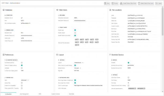
GST Web Admin
Last year we released the rewrite of GST Web. This year we also re-made the administrative part of GST Web. This completes the GST Web rewrite. The new GST Web Admin is better structured than the previous version and also allows you to review your changes prior to saving them.
Moreover, the cache creation and user management have been improved tremendously. The cache creation now runs asynchronously, allowing you to close the interface and return later. It also informs other users if the process is already running and about errors during the process. We have tested this with bigger datasets and long running cache creation processes and have not encountered any problems so far.
Changes in the user management remove the requirement to input the database user password allowing for better security and privacy while still giving you the highest flexibility. Additionally, there are now more granular options for the public user to control what they are allowed to do.
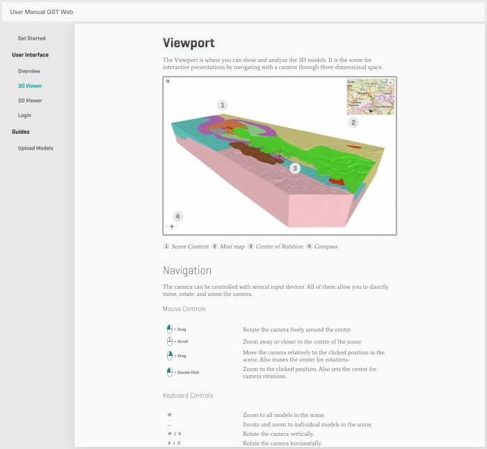
GST Web Manual
A rewrite of GST Web also requires a rewrite of the user manual for GST Web. The new manual is fully intergrated in GST Web itself and easily reachable via the „/manual“ URL.
Other Improvements
Of course there are a lot of other improvements that have been made. Here is a list of some which are particularly noteworthy:
- New Web Admin setting: Mutually exclusive models in the Model tree. When this is set, only one model (top level node) can be active at a time. Checking one model, will uncheck any other active one.
- In GST Web you can set the color for multiple features at once.
- GST Web improved the initial loading time when the cache is disabled significantly. For example, initial loading time improved from 25s to 2.5s on Bavaria’s internal instance.
- Across all GST parts we have had another look at UTF-8 support and reworked especially the display of umlauts in GST Web and GST Desktop
- GST API now uses login sessions which allows a faster response times in GST Desktop and GST Web
- We have done several dependency updates to allow a faster response times in GST Desktop and GST Web but also making sure that GST cannot be an easy target for attackers
- We optimized the geometry loading process allowing us to reduce the server RAM usage tremendously
- GST Desktop allows you to transform a non-constrained property into a constrained one. The property values will be used as key values for the constrained table.
- GST Desktop allows you to transform a constrained property into a non-constrained one. The property values hold the assigned key values as data.